
A trip to the past might be experienced with a historical map

A trip to the past might be experienced with a historical map
Historically, maps have been one of the most important innovations and have allowed humans to explain and navigate their way through the world, spreading information, technology, and culture. Some of the earliest surviving maps include cave paintings and etchings on stone or tusk. A renewed interest in classical works during the renaissance sparked a revival of maps becoming more like surveys than illustrations. By the fifteenth and sixteenth centuries, detailed depictions of the North American coast and interior were being produced by European nations. The historical importance of maps cannot be understated, and they have served as a link to the past and a way for historians to develop an understanding of how cultures have been shaped and evolved. The first map of the America's was produced by Spanish cartographer Juan de la Cosa during Columbus' first exploration of the New World. In 1519 Magellan completed the first
circumnavigation around the world, and cartography experienced a considerable advance in scope and technology with this expedition. For the first time in human history, the entire globe had been discovered and mapped. Magellan died in the Philippines during the journey, and his second in command, Juan Elcano, completed their expedition in 1522.
Maps are getting more accurate
The distinctive aesthetic and unique style of vintage maps give any space a cosmopolitan feel that can transport the viewer back in time, allowing them to create a bond between the past and present. Technological advancements in the eighteenth and nineteenth centuries allowed cartographers to develop more detailed depictions of towns, cities, and nations. Many different styles of historically important maps became popular not only for their information but also as decorative pieces. As boundaries shift and regions grow, maps allow the viewer to gain a historical perspective and develop a bond. From bird's eye perspectives to military, geopolitical maps, many different maps have been produced since as early as 2300 B.C. when the Babylonians made maps on clay tablets. The historical importance and preservation of every era's cartographical style is of particular note as technologies improved, and map accuracy achieved new heights. Political, thematic, and physical maps all show us different things about a place or region. From detailed road maps produced by the iconic Rand-McNally to early hand-drawn productions, the historical importance of maps relates to national interests and

transportation, travel, sailing, and more. Ancient Greek Anaximander is considered the father of the map, and it is presumed that his map portrayed the known world and depicted land and sea distinctly. From a historical perspective, this is considered the beginning of modern cartography in its earliest forms. As advancements in math and geography occurred, maps became more accurate and contained more references to geographic features. The establishment of the U.S. Geological Survey in the eighteenth century saw the production of numerous detailed, large-scale maps of North America, Mexico, and the Caribbean. These maps were later used in multiple land deals that would eventually become the modern international boundaries for the U.S., Mexico, and Canada.
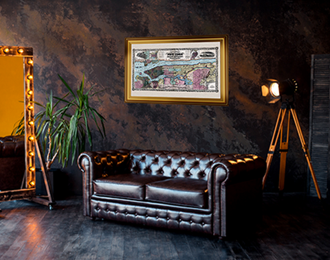
Limitless options for displaying an Antique map
Displaying antique maps not only highlights their historical importance but brings a piece of the past into the present. With the vast options for style, era, and location, the options are nearly limitless. From ornate depictions from the Classical and Neo-classical periods to pioneering early American cartographers who illustrated the nation from coast to coast, vintage and antique maps are not only historically significant but visually captivating.

