1856 Political Map of the United States of America Framed Wall Art – Historic Prints
100% Satisfaction Guaranteed: Free Returns
Free Standard Shipping
Get 10% OFF your First Order

Shop Now and Get Free Shipping to Anywhere in the United States and Puerto Rico.*

Follow us

Digitally Restored and Enhanced 1856 United States Map Poster - Framed Vintage Map of USA - Old USA Map Poster - United States Wall Map - Political Map of United States Wall Art
  • Load image into Gallery viewer, Digitally Restored and Enhanced 1856 United States Map Poster - Framed Vintage Map of USA - Old USA Map Poster - United States Wall Map - Political Map of United States Wall Art
  • Load image into Gallery viewer, Digitally Restored and Enhanced 1856 United States Map Poster - Framed Vintage Map of USA - Old USA Map Poster - United States Wall Map - Political Map of United States Wall Art
  • Load image into Gallery viewer, Digitally Restored and Enhanced 1856 United States Map Poster - Framed Vintage Map of USA - Old USA Map Poster - United States Wall Map - Political Map of United States Wall Art
  • Load image into Gallery viewer, Digitally Restored and Enhanced 1856 United States Map Poster - Framed Vintage Map of USA - Old USA Map Poster - United States Wall Map - Political Map of United States Wall Art
  • Load image into Gallery viewer, Digitally Restored and Enhanced 1856 United States Map Poster - Framed Vintage Map of USA - Old USA Map Poster - United States Wall Map - Political Map of United States Wall Art
  • Load image into Gallery viewer, Digitally Restored and Enhanced 1856 United States Map Poster - Framed Vintage Map of USA - Old USA Map Poster - United States Wall Map - Political Map of United States Wall Art
  • Load image into Gallery viewer, Digitally Restored and Enhanced 1856 United States Map Poster - Framed Vintage Map of USA - Old USA Map Poster - United States Wall Map - Political Map of United States Wall Art
  • Load image into Gallery viewer, Digitally Restored and Enhanced 1856 United States Map Poster - Framed Vintage Map of USA - Old USA Map Poster - United States Wall Map - Political Map of United States Wall Art
  • Load image into Gallery viewer, Digitally Restored and Enhanced 1856 United States Map Poster - Framed Vintage Map of USA - Old USA Map Poster - United States Wall Map - Political Map of United States Wall Art
  • Load image into Gallery viewer, Digitally Restored and Enhanced 1856 United States Map Poster - Framed Vintage Map of USA - Old USA Map Poster - United States Wall Map - Political Map of United States Wall Art
  • Load image into Gallery viewer, Digitally Restored and Enhanced 1856 United States Map Poster - Framed Vintage Map of USA - Old USA Map Poster - United States Wall Map - Political Map of United States Wall Art
  • Load image into Gallery viewer, Digitally Restored and Enhanced 1856 United States Map Poster - Framed Vintage Map of USA - Old USA Map Poster - United States Wall Map - Political Map of United States Wall Art
  • Load image into Gallery viewer, Digitally Restored and Enhanced 1856 United States Map Poster - Framed Vintage Map of USA - Old USA Map Poster - United States Wall Map - Political Map of United States Wall Art
  • Load image into Gallery viewer, Digitally Restored and Enhanced 1856 United States Map Poster - Framed Vintage Map of USA - Old USA Map Poster - United States Wall Map - Political Map of United States Wall Art
  • Load image into Gallery viewer, Digitally Restored and Enhanced 1856 United States Map Poster - Framed Vintage Map of USA - Old USA Map Poster - United States Wall Map - Political Map of United States Wall Art
  • Load image into Gallery viewer, Digitally Restored and Enhanced 1856 United States Map Poster - Framed Vintage Map of USA - Old USA Map Poster - United States Wall Map - Political Map of United States Wall Art

1856 United States Map - Framed Vintage Map of USA - Old USA Map - United States Wall Map - Political Map of United States Wall Art Poster

Regular price
$175.99
Sale price
$175.99
Regular price
$351.99
Sold out
Brand : Historic Prints
Unit price
per 

Feature Points

  • VINTAGE MAP FRAMED: You’ll love this high-quality framed historic reproduction of 1856 United States Map Poster. Our ready-to-hang maps are printed and framed in the USA by professional art framers using the highest quality materials. Each order is inspected for quality. This beautiful artwork is a perfect addition to your themed decor. Vintage maps look great in the home, study or office. They also make an unforgettable gift. 
  • A LOOK BACK AT HISTORY: This is an impressive, historic reproduction of 1856 Framed Map of United States. A true piece of history. Historic prints beautifully link the past with the present. You may find yourself staring at your historic wall art for hours in amazement. See our product description section for more fascinating information about this historic map and its significance.
  • PREMIUM QUALITY: To display this amazing piece of history, we use museum-quality heavyweight (230gsm), fine art print matte paper. Our paper is acid-free which allows the print to retain its color quality for generations. Our paper displays vintage map art with accurate color reproduction. This high quality print will be a wonderful addition to your vintage-themed wall.
  • READY TO HANG: This high-quality frame displays art beautifully in almost any environment. The frame is made out of poplar wood (for black and white) and pine wood (for walnut and natural) with a matte finish. The frame profile is 1.5 inches high and 0.75 (for size 18x24) and 1.125 (for size 24x36) inches wide. To protect artwork, we use high-quality, lightweight, shatter-resistant frame-grade acrylic. Frames arrive ready-to-hang, preinstalled with hanging hardware.
  • HISTORIC PRINTS: We love history and art. Sometimes old maps have tears, folds, stamps, separations and other blemishes. We digitally restore and enhance maps while keeping its historical character. Our framed prints are made-to-order in the USA by professional art framers. Customers all over the world love our historic prints and we know you will too.


Additional Information
 

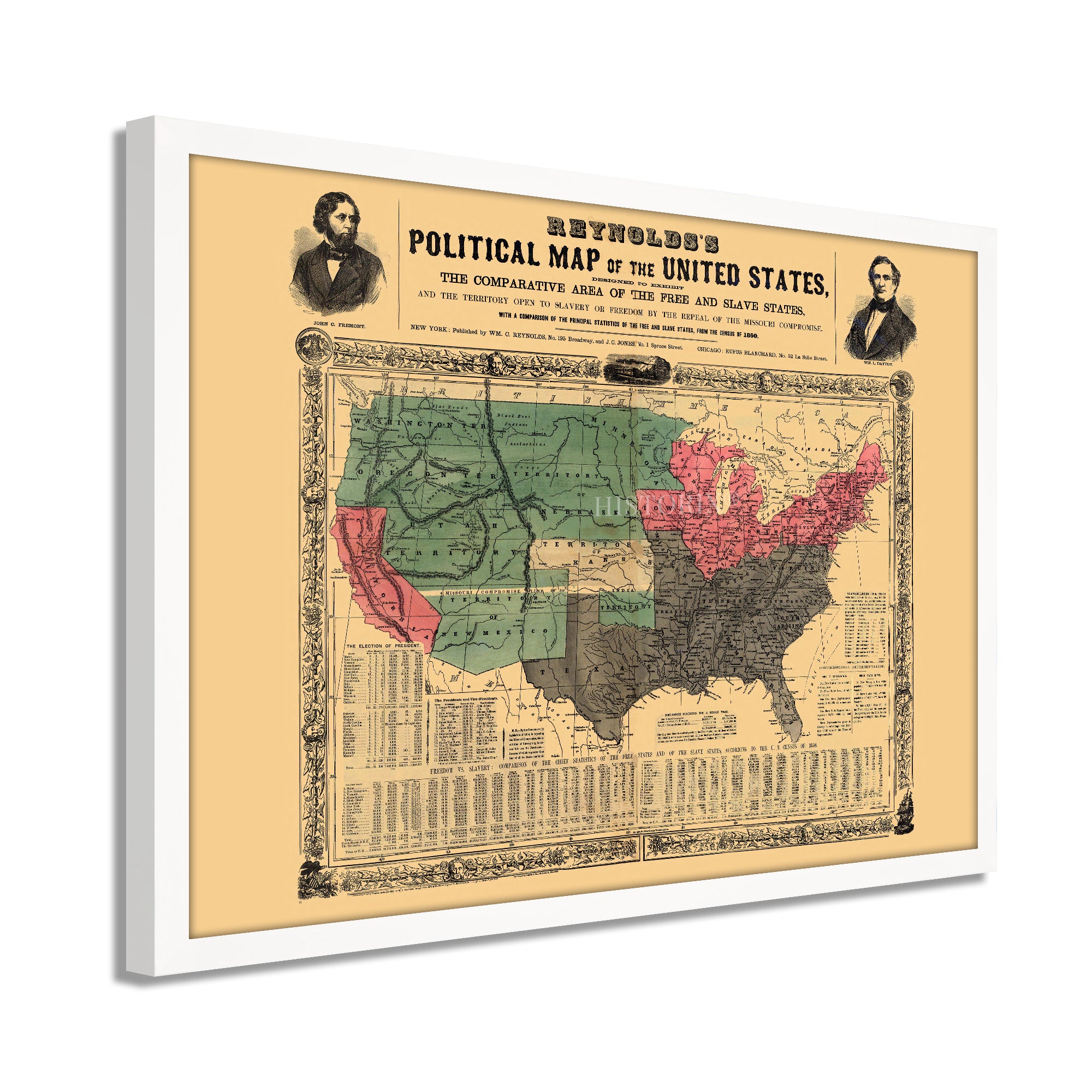
Published five years prior to the outbreak of the Civil War, this political map was produced to display the ongoing debate over free and slave states in the US and the territories that were under consideration for statehood’s stance on the issue. This rare map was one of the promotional tools employed in the 1850s Presidential campaign launched by John Fremont. Fremont was the first candidate put forward by the newly formed Republican Party, which had emerged after the dissolution of the Whigs.

Published in support of Fremont’s campaign, Reynolds differentiated free and slave states by color depicting free states in red, slave states in black, and territories in green. Reynolds, based in New York, rushed this map into production immediately after Fremont’s nomination in support of the anti-slavery candidate. The map attempted to sway voters with the notion that slavery could spread into the North if a non-anti-slavery candidate were elected.

The nation was divided on the issue, and the inclusion of the territories would prove pivotal to the leverage lawmakers had when determining free states versus slave states. Though this map did not accurately depict what the actual Union and Confederate boundaries would become as Kansas, Missouri, and West Virginia would remain under Union control. This map shows the nation marching toward conflict and illustrates the deep divisions created between the North and South. It’s distinctive aesthetic and unique purpose as a political campaign piece make this an authentic part of American cartographical history.

Our ready-to-hang wall art are printed and framed in the USA using the highest quality materials with professional craftsmanship. This beautiful artwork is a perfect addition to your themed decor. Historic prints look great in the home, study or office. They also make an unforgettable gift.

*Free shipping for framed and canvas products limited to the 48 contiguous United States.