1960 Map of Africa Administrative Divisions Wall Art Print – Historic Prints
100% Satisfaction Guaranteed: Free Returns
Free Standard Shipping
Get 10% OFF your First Order

Shop Now and Get Free Shipping to Anywhere in the United States and Puerto Rico.*

Follow us

Digitally Restored and Enhanced 1960 Vintage Africa Map - Vintage Map of Africa Administrative Divisions - History Map of Africa Poster - Old Africa Wall Art
  • Load image into Gallery viewer, Digitally Restored and Enhanced 1960 Vintage Africa Map - Vintage Map of Africa Administrative Divisions - History Map of Africa Poster - Old Africa Wall Art
  • Load image into Gallery viewer, Digitally Restored and Enhanced 1960 Vintage Africa Map - Vintage Map of Africa Administrative Divisions - History Map of Africa Poster - Old Africa Wall Art
  • Load image into Gallery viewer, Digitally Restored and Enhanced 1960 Vintage Africa Map - Vintage Map of Africa Administrative Divisions - History Map of Africa Poster - Old Africa Wall Art
  • Load image into Gallery viewer, Digitally Restored and Enhanced 1960 Vintage Africa Map - Vintage Map of Africa Administrative Divisions - History Map of Africa Poster - Old Africa Wall Art
  • Load image into Gallery viewer, Digitally Restored and Enhanced 1960 Vintage Africa Map - Vintage Map of Africa Administrative Divisions - History Map of Africa Poster - Old Africa Wall Art
  • Load image into Gallery viewer, Digitally Restored and Enhanced 1960 Vintage Africa Map - Vintage Map of Africa Administrative Divisions - History Map of Africa Poster - Old Africa Wall Art
  • Load image into Gallery viewer, Digitally Restored and Enhanced 1960 Vintage Africa Map - Vintage Map of Africa Administrative Divisions - History Map of Africa Poster - Old Africa Wall Art
  • Load image into Gallery viewer, Digitally Restored and Enhanced 1960 Vintage Africa Map - Vintage Map of Africa Administrative Divisions - History Map of Africa Poster - Old Africa Wall Art
  • Load image into Gallery viewer, Digitally Restored and Enhanced 1960 Vintage Africa Map - Vintage Map of Africa Administrative Divisions - History Map of Africa Poster - Old Africa Wall Art

1960 Africa Map Poster - Old Wall Map of Africa Administrative Divisions Poster Print - History Map of Africa Wall Art Poster

Regular price
$37.99
Sale price
$37.99
Regular price
$75.99
Sold out
Brand : Historic Prints
Unit price
per 

Feature Points

  • VINTAGE MAP REPRODUCTION: You’ll love this high quality historic reproduction of 1960 Vintage Africa Map. Our museum quality prints are archival grade, which means it will look great and last without fading for over 100 years. Our print to order maps are made in the USA and each map is inspected for quality. This beautiful artwork is a perfect addition to your themed decor. Vintage maps look great in the home, study or office. They make a perfect gift as well.
  • MUSEUM QUALITY: This high quality map print will be a great addition to your vintage-themed wall. Don't waste money on cheap-looking, thin paper posters. We use thick, fine art print quality matte paper. Our professional’s choice matte paper displays artwork in high detail without glare. The color is vibrant and text is easy to read. When framed, this map looks absolutely stunning.
  • A LOOK BACK AT HISTORY: This is an impressive, historic reproduction of 1960 Map of Africa Continent Wall Art. A true piece of history. See our product description section for more fascinating information about this historic map and its significance.
  • READY TO FRAME: This print includes a 0.2 inch border for a perfect frame fit and look. Our maps are designed to fit easy-to-find standard frame sizes, saving you money from having to pay for a custom frame. Each map is inspected for quality and shipped in a rigid tube.
  • HISTORIX: We love history and art. Sometimes old maps have tears, folds, separations and other blemishes. We digitally restore and enhance maps while keeping its historical character. All our maps are proudly made in the USA. Customers all over the world love our vintage maps and we know you will too.


Additional Information
 

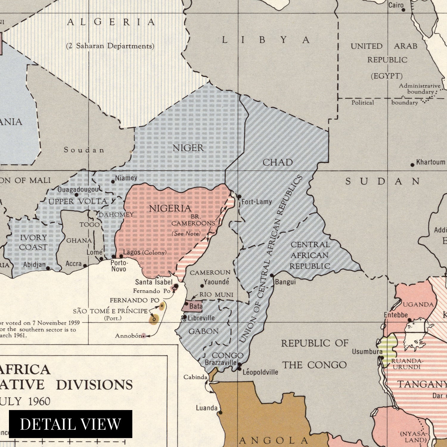
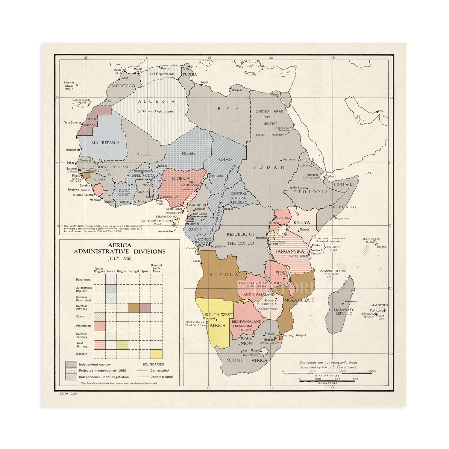
The postwar period marked a significant transformation throughout Africa as decolonization and independence movements made rapid advances. Numerous nations and republics were established following European rule and colonialization since the fifteenth century. Decolonization is considered to have started in 1951 with the liberation of Libya and peaked in the same year as this publication in what is now referred to as the Year of Africa when seventeen new nations were created. Many of these new states were in French West Africa, and the final new nation was founded in 1993 with Eritrea’s split from Ethiopia. 

The Central Intelligence Agency has produced geopolitical maps since 1941 and maintains the most up-to-date boundaries, borders, and shifts in national politics. These productions were vital for political and military leaders to develop and implement policy and strategize. Because of the large amount of newly formed nations in 1960, the CIA created this map of the new administrative divisions. One of the most notable aspects of this map is the lack of geographic features and that it only highlights certain capitals as the newly independent nations worked to form governments. 

As independent nations were formed, these geopolitical borders were impacted by traditional tribal boundaries, which had not been taken into account during the colonial period and created points of tension as new nations contained residents from diverse backgrounds. The twentieth century saw rapid development culturally, economically, and politically. This is an authentic piece of African cartographical history that immediately transports the viewer back in time.

Our museum quality giclee print comes printed with archival ink on premium heavyweight matte paper. Shipped in a sturdy cardboard tube your print will arrive ready to be framed. This eye-catching vintage map reproduction makes the perfect gift for anyone that loves history and imagery.

*Free shipping for framed and canvas products limited to the 48 contiguous United States.